
Clandestine signals, a courageous rider, shouts in the dark, and suddenly roused patriots rallying to defend their homes and liberties. The most famous midnight gallop in American history is as indelible a piece of national lore as they come, celebrated in verse and myth.
For such a fabled journey, you might think Paul Revere’s route would be lined with reminders of his epic dash. But parts of three days spent walking the 17-mile route from Charlestown to Lincoln revealed little love for the rebel messenger.
Sure, there’s the Paul Revere Restaurant in Medford, a location the famed patriot passed 163 years before the breakfast-and-lunch spot opened in 1938. And there are roads named for him in Arlington and Lexington that give a nod to the history that sped through there.
But if you’re looking for much more signage to show the way, whether written in black and white or chiseled in stone, you’re out of luck. The Revere connection, pretty much, cannot be found anywhere else along the route.
The route begins on busy Warren and Main streets in Charlestown, where Revere set out under a waning gibbous moon; curves around congested Sullivan Square to Broadway in Somerville; veers off Winter Hill to Main and High streets in Medford; and joins Massachusetts Avenue in Arlington before heading to Lexington, crossing Interstate 95, and ending on Battle Road in Lincoln.
It’s dotted with bodegas and nail salons, cushy homes and three-deckers, and its noisy highways and quiet streets are emblematic of today’s metropolitan Boston. But there’s history beneath that modern asphalt; they were once country roads that Revere knew well as he awakened Minute Men and others during the late night and early morning of April 18 and 19, 1775.
Lexington native Francine Daveta, serving diners at Il Casale close to that town’s Battle Green, need only peer outside the restaurant windows to see the section of Massachusetts Avenue that Revere traversed to warn rebel leaders John Hancock and Samuel Adams, staying at a nearby home, that the British were on the move.
“It’s definitely ingrained in us,’’ Daveta said of Revere’s route. “But I don’t think I appreciated it as much as a teenager as I do now.’’
Today, these streets from Charlestown to Lincoln are generally just a means to get from one place to another, and many people are likely not aware they are literally driving on history. For the curious pedestrian, though, the National Parks of Boston provided a turn-by-turn digital map, with a thin red line overlaid on the modern roadways.
Setting off from Charlestown
The path-finding puzzle begins near the USS Constitution in the Charlestown Navy Yard, where a modest plaque and nearby text show where Revere was rowed ashore from Boston’s North End to begin his ride. The markers are tucked into a dead-end corner of the Harborwalk, obscured from broad public view behind the obstacle of a fenced-off demolition site.
Once on nearby Warren Street, Revere’s route passes below the towering Bunker Hill Monument and proceeds to Thompson Square before merging with Main Street for a dusty, horn-honking trek to the pedestrian nightmare that is Sullivan Square.
Today, a jumble of weeds, Jersey barriers, and irritated commuters in bumper-to-bumper traffic makes the circle a place to leave behind as quickly as possible. In 1775, Revere had another reason to bolt from here. A grisly example of Colonial jurisprudence awaited him nearby.
“After I had passed Charlestown Neck and got nearly opposite where Mark was hung in chains, I saw two men on horseback under a tree,’’ Revere wrote later. “When I got near them, I discovered they were British officers. One tried to get ahead of me, and the other to take me.’’
Revere reversed course, galloped away, and outran the Redcoats as he fled up what is now called Winter Hill in Somerville and toward neighboring Medford. And Mark? Those were the publicly displayed remains of an enslaved Black man who had been hanged 19 years earlier after his owner was murdered.
Revere’s mention of the gruesome sight is a reminder that many in Massachusetts held enslaved people as the Revolution approached. Was Revere appalled by the sight, or was he simply name-checking a well-known marker for locals? (Revere did not have slaves.)
When Revere reached Medford and headed toward Arlington, he crossed and re-crossed the Mystic River, passing the Isaac Royall House along the way. The mansion, home to a wealthy enslaver and Loyalist, today stands two blocks from Pinky’s Famous Pizza near Medford Square.
Revere also passed the nearby residence of Sarah Bradlee Fulton, a patriot who nursed the wounded from Bunker Hill in a nearby field hospital. Plaques and signs near Mystic Valley Parkway mark the history of these people and places. Still, nothing of Revere.
Finally, in West Medford, Revere is given his due at the High Street restaurant that bears his name. Fronting the road Revere took into nearby Arlington, then called Menotomy, the 87-year-old eatery advertises “hot coffee to go!’’ as well as soups, sandwiches, and lunch specials. Outside, American flags and faux Easter eggs adorn a few planters. Inside, early American flags and Revere statuary set the tone.
Farther along, past the Regent Theatre in Arlington, the route turns to the right at a Starbucks on Massachusetts Avenue, passing the Jason Russell House, where bloody fighting occurred during the British retreat to Boston on April 19, 1775.
‘The night is always very still there’
Early Saturday morning, Rory Thomas Nolan of Newburyport, a reenactor who plays a British sergeant in the 52nd Regiment of Foot, will march by the house after midnight as his group traces the Redcoat route from Boston to Lexington.
For Nolan, it will be the 16th time he has made the long walk, and the reenactors will pause to recall what occurred there 250 years ago. Twelve Colonials were killed in fighting at the house, as well as two British soldiers.
“The night is always very still there, and recounting such harrowing events in such quiet can be a bit chilling. But places like these are good reminders of the struggles those that fought that day faced,’’ Nolan said.
Their struggles, he added, help “keep us focused on picking up our pace and huffing it to the next rally point on the march. Which, for us, is the Trader Joe’s, where we switch onto ye olde Minuteman bike path.’’
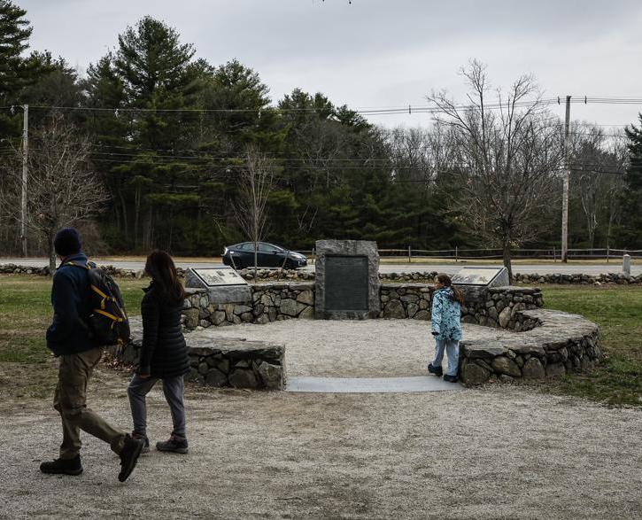
That path, off Massachusetts Avenue, leads to Lexington Center, where it’s only a few miles to Battle Road, the gravel pathway in Minute Man National Historical Park that mimics the 18th-century Bay Road, which the British followed to and from Concord in their harrowing, 40-mile round-trip.
Revere and two riders who joined him for this stretch, William Dawes and Dr. Samuel Prescott, were intercepted in Lincoln by a British patrol. Dawes and Prescott escaped, but Revere was arrested and interrogated.
“Major Mitchell of the 5th Regiment clapped his pistol to my head, called me by name, and told me he was going to ask me some questions,’’ Revere wrote later in a letter to Jeremy Belknap of the Massachusetts Historical Society. “And if I did not give him true answers, he would blow my brains out.’’
The patrol eventually took Revere’s horse, and he ended up walking back to Lexington, where he rejoined Hancock and Adams and told them what had happened. The duo, also fearing arrest, decided that heading toward Woburn was a good idea.
Revere, meanwhile, collected a trunk of incriminating papers they had left behind. He would not return to Boston until the British evacuated the town nearly a year later.
A detail from a painting by Robert Reid of Paul Revere’s ride from the Hulton Archive of Getty Images.
Brian MacQuarrie can be reached at brian.macquarrie@globe.com.